
If you are young and fit and want to climb a volcano, then
go to Guatemala Guatemala
 |
| Plate Tectonics in action |
Along the eastern side of the Pacific Ocean, following
Central and South America, there is an elongated 'Subduction Zone" whereby
the continental crust of Central and South America
is thrust over the Oceanic crust, causing earthquakes and melting of the newly
buried material. This magma is squeezed upwards and forms volcanoes at the
surface, maybe one volcano every 50 kms along the mountain chain of the Andes
and in Central America .
Wikipedia lists 29 volcanoes for Guatemala
all lying in the SW Highland region close to the Pacific
Ocean and having elevations of 1200 to 4200 metres. Two are recorded as being active, Pacaya and
Fuego, the later's eruptions causing much damage and casualties at present (May 2018). The Pacaya volcano (2552 metres) is a favorite one for backpackers to climb via organized tours from the tourist city of Antigua (the old capital). I tried this out but was defeated by gale force winds on nearing the summit. It was impossible to stand up. The only way up was to crawl on the steep ash slope. Not good.....so we retreated down to shelter in the forest, and so back down the track to the parking lot where our bus awaited.
The volcanoes make for lovely photographic backgrounds to the tourist regions centered by the towns
Antigua, and Panajachel on Lago Atitlan. Some volcanoes often give a puff of smoke, just to remind us that the fires below are still smoldering. Antigua, population now about 30,000, the original capital of Guatemala, was founded by the Spaniards in 1542. It was so continuously devastated by earthquakes and volcanic eruptions that the capital was moved in 1775 to what was considered to be a "safer" region" called "Guatemala City" having now about 2 million inhabitants.
Antigua remains a beautiful tourist town whose skyline is dominated by a trio of volcanoes having sinister reputations.....they appear on the city's coat of arms. Volcan Agua lies to the SE, Fuego is SW, and Acatenango is to the west, all about 3700 metres high. Volcan Agua is about a 5 hour climb to the top. Fuego is out of bounds as it is erupting at present.
Lago Atitlan is a caldera lake of volcanic origin. It measures about 10 km across and 25 km wide. It was formed about 1.8 million years ago when a super-duper volcanic explosion took place that blasted a hole in the region, which subsequently filled up with water. It is estimated that about 300 cubic kms of material, mainly tephra, was ejected and covered the region as far away as Florida and Ecuador. At a later date new volcanoes sprouted up around the rim of the caldera which are the ones we see today. The super eruption that formed the crater lake is known as the Los Chocoyas eruption, being named after a bird that makes its nest in the soft ash.
Lago Atitlan is a major tourist attraction of the Western Highlands. The small villages found around the lake shore are accessed by boat from Panajachel, the main town on its shore. The village of San Pedro, across the lake at the foot of Volcan San Pedro, is a very popular place for tourists and backpackers, for experiencing the local cuisine and also for attending Spanish language schools. Growing and processing coffee is a local industry. The lake was stocked with black bass in 1958. I did see one caught from the shore, of about 3 lbs, on a spinner. I had no luck. Lago Atitlan is a place where you could happily disappear for ever. Many backpackers are doing just that.
Regards from Allano
The volcanoes make for lovely photographic backgrounds to the tourist regions centered by the towns
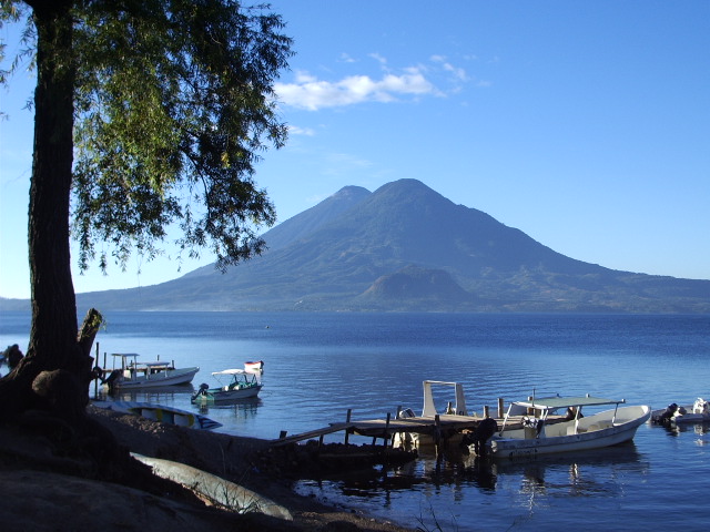 |
| Lago Atitlan, with Volcanoes Toliman 3158 m, and Atitlan 3537 m, in the background. |
Antigua remains a beautiful tourist town whose skyline is dominated by a trio of volcanoes having sinister reputations.....they appear on the city's coat of arms. Volcan Agua lies to the SE, Fuego is SW, and Acatenango is to the west, all about 3700 metres high. Volcan Agua is about a 5 hour climb to the top. Fuego is out of bounds as it is erupting at present.
Lago Atitlan is a caldera lake of volcanic origin. It measures about 10 km across and 25 km wide. It was formed about 1.8 million years ago when a super-duper volcanic explosion took place that blasted a hole in the region, which subsequently filled up with water. It is estimated that about 300 cubic kms of material, mainly tephra, was ejected and covered the region as far away as Florida and Ecuador. At a later date new volcanoes sprouted up around the rim of the caldera which are the ones we see today. The super eruption that formed the crater lake is known as the Los Chocoyas eruption, being named after a bird that makes its nest in the soft ash.
Lago Atitlan is a major tourist attraction of the Western Highlands. The small villages found around the lake shore are accessed by boat from Panajachel, the main town on its shore. The village of San Pedro, across the lake at the foot of Volcan San Pedro, is a very popular place for tourists and backpackers, for experiencing the local cuisine and also for attending Spanish language schools. Growing and processing coffee is a local industry. The lake was stocked with black bass in 1958. I did see one caught from the shore, of about 3 lbs, on a spinner. I had no luck. Lago Atitlan is a place where you could happily disappear for ever. Many backpackers are doing just that.
Regards from Allano
 |
| Yes, I'll buy that. |
 |
| No thanks, I don't want to buy a chook. |
No comments:
Post a Comment