School girl in Panajachel, Guatemala, selling fabrics. She says "Why don't you buy my stuff?" I gave her a little Australian flag.

Tuesday, July 3, 2018

BURNING AWAY MISFORTUNES IN ECUADOR

Author:  Allan Taylor     This article was first added 19 years ago to the Travel site "BootsnAll"; now I have added it to my Travel Blog "Rolling Stone" 4th July 2018 as it has important political significance to Australia.

Burning Away Misfortunes…..Ecuador
By Allan Taylor
New Year’s Eve is always a night for celebration. In most countries people celebrate the coming of the New Year.  Ecuador is unique by having a ceremony to say goodbye to the Old Year.  All throughout the country on the 31st of December, young people and old go to extraordinary efforts to maintain one of the magical traditions of Ecuador.

Symbolism is rife. The Old Year, or “Ano Viejo” is represented by various creations. A model house is made of branches and burnt to ashes. Life-size dummies, akin to our Guy Fawkes, made of sawdust and dressed in old clothes, are sold in the streets. Ornate masks are sold for adornment of the dummies.

The idea is to represent some happening, activity, or person, that has resulted in a negative impact on the community, or your well-being. Often this is a politician, judge, army leader etc, whose actions you disapprove of. The appropriate mask is worn by the dummy. A controversial political happening may be the subject of a very elaborate construction, which is put to the torch at midnight. What a great idea for Australia!

The creativity of the people is encouraged by having a competition for the best effort. In Cuenca, where I was, the Amistad Club and Azuy Union of Journalists organise such competition. You have to register your creation and explain what or who it represents and detail why public notice should be focused thereon. A jury of Club members commences its tour of exhibits at 4pm and deliberates over events. Prizes are given. What a rich feed stock for newspapers the next day!

The final day of the Old Year is lots of fun. Young people dress up as widows, witches and skeletons, etc, symbolic of the Old Year. They stop cars in the street and beg for a donation, which I suspect goes to buy fireworks. I approached a group of kids in fancy dress on a Cuenca street and admired their dummy.

“This is the President of Ecuador” they inform me proudly. “Can I take a photo of him?” I ask, slipping a few thousand sucres into an outstretched hand.

I admired a fancy procession of floats with pretty girls on horseback, that stopped briefly at a church for a blessing. Towards dusk, the centre of town around San Francisco Church and the market is blocked off to vehicular traffic. From the balcony of my room in Hotel Milan, I watched in amazement as people stacked wood for bonfires in the middle of the street. The quantity of rockets and bangers available was enough to start a revolution. I pondered over events, safe in my hotel eyrie, camera at the ready, fortified with rum and Coke, watching all these preparations for who knows what?

Periodically I ventured down to street level for an empanada, and to see what was going on. Close to midnight the groups in the plaza below lit their bonfires. Sparks were flying from a particularly big construction one block away. I watched them beat the dummies with sticks and then hurl them onto the bonfire. There was great cheering and revelry as the dummies burst into flames and sky rockets soared into the night.

The outcome of the burning is that it releases a great euphoria. Misfortunes and bad memories of the past year are burned away. There is a purification of one’s thoughts. The path ahead is made clear for new hope and happiness. In this moment, resolutions for the New Year are made. The old year has gone. There is hugging and kissing and tears. The celebration of the Old Year in Ecuador is a wonderful tradition and truly a magical event not to be missed.
Regards from Allano

Handling the dummies for sale.

Friday, June 8, 2018

GUATEMALA....LAND OF VOLCANOES


If you are young and fit and want to climb a volcano, then go to Guatemala, its got dozens of them, mostly in the height range of 3500 to 4000 metres., so you'll get a good view from the top. Also, Guatemala is a great country to travel in once you get used to and learn to enjoy the Indian culture and cuisine.  Some backpackers seem to have moved in for good at villages around Lago Atitlan, located in the Western Highlands, which is a popular tourist region.

Plate Tectonics in action
Guatemala lies on the Pacific  "Rim of Fire"  which is important in explaining the concentration of volcanoes around the rim of the Pacific Ocean.  The geological theory of "Plate Tectonics" was founded as recently as 1960, and explains how mountains are built and volcanoes are born.  The continents are considered to be rigid plates (the SIAL, or a silicious scum) which move around by plastic flow on top of the earth's mantle, which has a denser composition (the SIMA).  Movement rate is about 10 cm per year, so in a million years a continent could move a 100 kms. 

Along the eastern side of the Pacific Ocean, following Central and South America, there is an elongated 'Subduction Zone" whereby the continental crust of Central and South America is thrust over the Oceanic crust, causing earthquakes and melting of the newly buried material. This magma is squeezed upwards and forms volcanoes at the surface, maybe one volcano every 50 kms along the mountain chain of the Andes and in Central America.

Wikipedia lists 29 volcanoes for Guatemala all lying in the SW Highland region close to the Pacific Ocean and having elevations of 1200 to 4200 metres.  Two are recorded as being active, Pacaya and Fuego, the later's eruptions causing much damage and casualties at present (May 2018). The Pacaya volcano (2552 metres)  is a favorite one for backpackers to climb via organized tours from the tourist city of Antigua (the old capital). I tried this out but was defeated by gale force winds on nearing the summit.  It was impossible to stand up.  The only way up was to crawl on the steep ash slope.  Not good.....so we retreated down to shelter in the forest, and so back down the track to the parking lot where our bus awaited.

The volcanoes make for lovely photographic backgrounds to the tourist regions centered by the towns
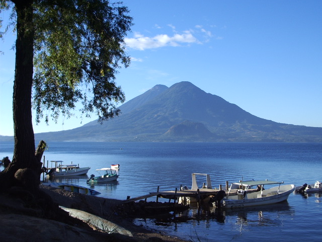
Lago Atitlan, with Volcanoes Toliman 3158 m, and  Atitlan 3537 m,
 in the background.
Antigua, and Panajachel on Lago Atitlan. Some volcanoes often give a puff of smoke, just to remind us that the fires below are still smoldering.  Antigua, population now about 30,000, the original capital of Guatemala, was founded by the Spaniards in 1542.  It was so continuously devastated by earthquakes and volcanic eruptions that the capital was moved in 1775 to what was considered to be a "safer" region"  called "Guatemala City" having now about 2 million inhabitants.

Antigua remains a beautiful tourist town whose skyline is dominated by a trio of volcanoes having sinister reputations.....they appear on the city's coat of arms.  Volcan Agua lies to the SE, Fuego is SW, and Acatenango is to the west, all about 3700 metres high.  Volcan Agua is about a 5 hour climb to the top.  Fuego is out of bounds as it is erupting at present.

Lago Atitlan is a caldera lake of volcanic origin.  It measures about 10 km across and 25 km wide.  It was formed about 1.8 million years ago when a super-duper volcanic explosion took place that blasted a hole in the region, which subsequently filled up with water. It is estimated that about 300 cubic kms of material, mainly tephra, was ejected and covered the region as far away as Florida and Ecuador.  At a later date new volcanoes sprouted up around the rim of the caldera which are the ones we see today.  The super eruption that formed the crater lake is known as the Los Chocoyas eruption, being named after a bird that makes its nest in the soft ash.

Lago Atitlan is a major tourist attraction of the Western Highlands.  The small villages found around the lake shore are accessed by boat from Panajachel, the main town on its shore.   The village of San Pedro, across the lake at the foot of Volcan San Pedro, is a very popular place for tourists and backpackers, for experiencing the local cuisine and also for attending Spanish language schools.  Growing and processing coffee is a local industry.  The lake was stocked with black bass in 1958.  I did see one caught  from the shore, of about 3 lbs, on a spinner.  I had no luck.  Lago Atitlan is a place where you could happily disappear for ever.   Many backpackers are doing just that.
Regards from Allano

Yes, I'll buy that.

No thanks, I don't want to buy a chook.


Sunday, June 3, 2018

ON FOSSIL BEACHES


Rocks have lots to tell us if you speak their language.  You have to be a geologist to have a rapport with rocks, minerals, and gemstones.  Fossil shells are fairly common place and make for interesting initial collections for hikers exploring the outdoors.    But a fossil beach?  I have found some amazing ones in my travels.

A fossil beach denotes shallow water, such as found in a sea water estuarine system.  A current or tidal flow may create ripple marks over extensive areas of flat beach.  These ripple marks can be preserved when covered over by later deposits of sand and mud.  This can happen with terrestial flooding from rivers, or from regional subsidence.  It happens frequently.   The amber deposits of Guatemala are found in such sedimentary rocks of estuarine origin.

Jo standing by a fossil beach in the Adelaide Hills
But what about close to home where I live?  In the Adelaide Hills, between the suburbs of Belair and Mitcham there is a quartzite quarry with a wonderful exposure of ripple marks. It's on the steeply dipping side of the quarry wall of fine sandstone of the Kanmantoo basement rocks, and is about 400 millions old.

It is a nice afternoon scramble down hill northwards down the gully and so to Mitcham metro station.  Take the train both ways. Enjoy the city views, take a lunch. Watch out for the local wild life, the koalas, the foxes, and on hot days beware of brown snakes slinking around in the shrubbery.

The most spectacular fossil beach I have encountered is rather difficult to get to.  It forms the exposed crest of the Spero Range inland from Bathurst Harbour in South West Tasmania. It is composed of flat lying glaringly white quartzites of Pre-Cambrian Age, and looks like a ripple marked sandy beach formed just yesterday.  It invites you to strip off and dive into the water, but the tide went out maybe 800 million years ago (see Tasmanian Mines Dept Ref. below).


Dinosaur footprints in Bolivia…..being inspected by  Philippa Haselgrove,  from Adelaide.  (click to enlarge image)

Sometimes creatures have walked along these ancient beaches and have left their footprints.   Not human beings of course, for it was before their time.   Go back a 100 million years or so and you may encounter evidence of dinosaurs out for a stroll along the beach, leaving footprints of Mum or Dad and the youngsters in the sand, and the dragging furrow of their long tail.   A good example of this is in Bolivia, at a cement works quarry near Sucre. Take at taxi out to see the sights.  The steeply dipping mudstone of the quarry wall  is covered in dinosaur footprints, both large and small, made by Tyrrannosaurus rex , having feet up to 80 cm across,  and of a smaller iguanodon.    

So the rocks do speak to us and have a lot to say about how they were formed.  You may find rocks with fossil shells on the Adelaide beaches and elsewhere, which make nice ornamental pieces for display at home.  They will remind you that all the present political skulduggery is just a flash in geological time, so don't worry too much about it.    Regards from Allano.

An Adelaide sandy beach at Brighton....no dinosaurs here.
SW Tasmanian geology and Spero Range ripplemarks.
http://www.mrt.tas.gov.au/mrtdoc/dominfo/download/TR4_34_46/TR4_34_46.pdf

Old  quarry in Adelaide Hills showing ripple marks.


Foto opposite: Having a picnic with Joanna, Christobel and dog Jarrah in the old quarry showing ripple marks on the sloping walls.   The track down from the road above is rather steep so be careful.  The area is well signposted giving the history of the workings.  It's a nice outing on a summer's day.

Regards from Allano


PS: I have found some more dinosaur footprints.   These ones are preserved for tourists to look at near Mendoza in Argentina.   (Click to enlarge images)

Thursday, January 1, 2015

Southern Lakes Crossing - Chile to Argentina


The southern lakes crossing takes you from Chile to Argentina, or vice versa, through the Andean mountain chain at one of its most spectacular scenic regions. The route taken by bus and catamaran cruiser on the lakes is a great tourist attraction that takes a day in summer or two days in a snowy winter, but there is an optional stay-over at the Peulla or Natura Hotels at the head of the lake. The trip is between Puerto Varas, near the sea coast of Chile, inland to cross the Andes to San Carlos de Bariloche (Bariloche for short) which is the tourist center for the Argentine Lake District. The total distance is roughly 180 kms, and the road goes through the forested mountain pass of Perez Rozales at an altitude of 1022 meters, which is close by to snowy Cerro Tronador reaching 3460 meters.

The start on the Chilean side with the catamaran waiting at the jetty at Petrohue on Lago Todos Los Santos.


The eroded volcanic cone of Puntiagudo (2190 meters) on the skyline in Chile.

The details of the trip, schedules and prices are given by the operators Cruce de Lagos.
The traveller to this part of Chile may have reason to cross the Andes to Argentina in other regions which are listed in my Bootsnall travel article Southern Lakes Crossing

Tuesday, December 30, 2014

The Beagle Channel, Tierra del Fuego


Tierra del Fuego is the big island located at the very southernmost tip of South America. The Beagle Channel provides a safe southern route lengthwise from east to west, allowing ships to bypass the treacherous Cape Horn further to the south. This narrow channel through the mountains is named after Captain Robert Fitzroy's ship the "Beagle", used during a British surveying voyage of 1834. On board was Charles Darwin the ship's naturalist and recorder of the expedition. His account is now a classic book and collector's item, the "Voyage of the Beagle" , which was a precursor of Darwin's Theory of Evolution.

The Beagle Channel has spectacular mountain scenery with many glacier-filled fiords joining up with the channel. The best way to see everything is to take the weekly cruise ship "Terra Australis" (ca 120 passengers) from the Chilean port of Punta Arenas on the Strait of Magellan. The cruise goes easterly along the Beagle Channel to as far as Puerto Williams, which is a Chilean naval base on island of Navarino. Next port of call is to the northern shore and the Argentine port of Ushuaia, which is an important tourist and industrial town on the Argentine side of Tierra del Fuego. At Ushuaia the cruise ship drops off and takes on passengers and goes westward back along the channel to Punta Arenas, taking 6 days in all. When I did the cruise I left the ship at Ushuaia to explore that part of Tierra del Fuego for 10 days, then returned overland by bus to Punta Arenas


Docking at Ushuaia early in the morning. Snow still on the hills early November.


Old Chilean gun emplacement near Puerto Williams, one time guarding the Beagle Channel from intruders.

Allano views the Beagle Channel from the top of Cerro Bandera at Puerto Williams.

Friday, December 26, 2014

A visit to Volcan Masaya in Nicaragua


Volcan Masaya is an active volcano close to Managua, the capital of Nicaragua. It is part of Parque Nacional Volcan Masaya with over 20 kms of hiking trails. However, you don't have to climb to the top because a road goes to the summit giving a view from the crater lip. Half way there is an excellent museum which explains all about the park and the volcanism of the region.
(Click on fotos to enlarge)


The Spaniards regarded this volcano as the Gates of Hell. Masaya last erupted in 1772. The highest point of the crater lip, with a large cross on top, is at 632 meters. There is a hiking trail to the top now closed for it being too dangerous. Parrots (chocoyos) nest in tunnels made in the soft volcanic ash of the crater walls.


Lunch time sitting at the Plaza Central in Granada city, Nicaragua.

The horse drawn cabs are for hire. It's nice to take one for a trip to the lake shore a few kms away.

Friday, December 19, 2014

Isla Grande de Chiloe .... a glimpse at historic Chile


Isla Grande de Chiloe, or Chiloe for short, is a favorite Chilean island of mine, for to disappear in for a week or more, to eat at seafood restaurants and drink vino, and just enjoy myself for awhile at little cost. The island measures some 180 km long and 50 kms wide and is only a short ferry trip from Puerto Montt, the capital of the Chilean Lake District.


Fuerte San Antonio guards the town of Ancud (pop 25,000) a northern fishing port and Chiloe's largest town. The fortress was built by the Spanish and was their last Chilean outpost, until their final defeat in 1826. Other major towns are Castro (central) and Quellon the southern fishing and ferry port, all located on the relatively sheltered eastern side of the island.


(click on fotos to enlarge)
Churches on the island are of distinctive design and built of wood with wood shingle cladding. Likewise houses are wooden with shingles and a corrugated iron roof.

Market day at Dalcahue, a small fishing village near Castro.

The main commercial activities of the island are fishing, salmon farming, tourism and transport. At Ancud you must visit the fishing fleet when it's in port and look in at the fish processing plant adjacent to the wharf. Salmon and shellfish farming is done in the sheltered shallow inlets of the east coast out from Castro. The island of Chiloe is used as a convenient transport route to the fiordland part of Chile because the mainland route is too mountainous. Buses and trucks go from Puerto Montt to Ancud, thence south thru Castro to the ferry terminal at Quellon. The ferries (transbordadores) go south to Puerto Chacabuco to service the Aisen Region including Coihaique. The ferry also goes eastward to the main land to the port of Chaiten, which was wiped out by a volcanic eruption in 2008.

Thursday, December 18, 2014

Puerto Varas, Chile .... a great place to chill out in


Puerto Varas is a popular tourist town in the Chilean Lake District. Situated on the shores of Lago Llanquihue (= yankeeway) it is very pretty and small enough to walk around from your hotel or hospedaje. You can hike up the hill of Cerro Calvario beyond the railway line to admire the fantastic view of the lake and distant volcanoes of Osorno and Calbuco covered in snow.


The Plaza de Armas is close to the foreshore where you can stroll in the mornings or evenings and watch how the local lads catch a trout (1 to 2 lb) with a spoon lure from the end of the muelle (stone jetty). Nearby is the Casino and a small craft market, and a tour agency that will arrange for you a "Southern Lakes Crossing" to Bariloche in the Argentine Lake District.


Many of the hotels and hospedajes are on the flat near the Plaza de Armas and the Avenida Costanera which follows the lake foreshore. It is very pleasant taking the evening stroll and watching the activity and then maybe check out the Casino for a drink.

Artisans display their jewellery on a blanket and hope for a sale. The national gemstone of Chile is lapis lazuli of which there is some production from a site in the Andes north of Santiago. The blue of lapis lazuli blends in well with silver as rings and pendants.

A fun day may be had by taking the minibus to nearby Puerto Montt and perusing the wonderful craft market stalls along the road to Angelmo, the fishing port. It is easy here to spend a lost afternoon by having lunch at one of many dinky seafood restaurants. You will arrive back in Puerto Varas well fed and happy with your day's outing.

Saturday, December 13, 2014

Cape Town....the tourist jewel of South Africa


Cape Town is an unforgettable city and is the tourist jewel of South Africa (or even Africa as a whole, but I am diplomatic). It is Table Mountain that makes it great. The city sprawls around the base of this flat-topped mountain which has welcomed mariners from afar looking for a safe haven and fresh provisions.
Foto above: The Lion's Head from the summit of Table Mountain. Click on fotos to enlarge.

Once you have settled in to your accommodation your first challenge is to climb Table Mountain and get a broad picture of the place. Fortunately there is a cable car going up to the summit which makes life easy. However there is no point in going up there on cloudy day when the "table cloth" is set, for you will see nothing. Watch the weather and pick your fine day. A mini-cab will take you to the cable car terminus, and a little further on to the Kloof where the hiking track starts, if you are that energetic. Details are given in my Bootsnall article Table Mountain

I have found Cape Town backpacker establishments very efficient. Always there is a "travel desk" where they will organize local tours or book you on the Baz Bus to go off on the Garden Route. Advice on "what's on this week" and city maps are forthcoming. When visiting Cape Town I usually take a tour somewhere, my favourite being a wine region tour like to Stellenbosh and nearby wineries.

Mementos to take home? Obviously nothing bulky. I always check out the textiles and traditional fabrics to buy as gifts for friends. Wall hangings, table cloths, table runners, scarfs, sarongs etc are often brightly coloured, and clothing items made from traditional fabrics. Jewellery made from beads and shells are worth inspection.

Cape Town is a fun city to explore. You wont be disappointed and will come back time and again to relax amidst wonderful beach and mountain scenery.

Sunday, November 30, 2014

South Africa's Garden Route


The southern coastal route between Cape Town and Port Elizabeth, known as the Garden Route, is the premier tourist attraction of South Africa. This is a distance of about 800 kms travelled by bus or car, private or rental. At each end, or in the middle at the town of George, you can hop on a plane and return to the hinterland at Johanesburg, and so go on to other destinations.

You need at least two days and preferably a week or more to "do" the Garden Route. The favourite single stopover is the seaside resort town of Knysna with its nice harbour, yacht club and many seafood restaurants. The route is very popular with backpackers and budget accommodation abounds. The unique backpackers' Baz bus services the region and makes it easy to stop off en route. A typical backpackers would be Wildfarm located near Wilderness. The Baz bus calls in and they pick up travelers at the George airport. You don't need a car as the staff run a shuttle service to local sights, including the beach, Knysna and Wilderness.
(Click on fotos to enlarge)


The Garden Route relies primarily on tourism for its prosperity. Transport, accommodation and services related to tourism are what keeps the cash register tinging. The top attractions are the beautiful ocean beaches with their whale watching, diving, surfing and fishing. Each little seaside resort town around Wilderness has a unique attraction linked up by an antique tourist steam train. A little inland is the popular Cango Caves in a limestone region where you can cool off underground in a world of stalactites and stalagmites.

Ostrich farms are a tourist attraction. You get to ride and "race" ostriches, and at one backpackers I was served an ostrich egg omelette for breakfast. Details of a visit to an ostrich farm are given in my Bootsnall article Oudshoorn

Not to be missed at backpackers is an evening braai, or friendly barbecue washed down with the local beer or vino. It is a good way to meet up with fellow travelers. Each of the stop over points listed above have their accommodation websites listed ranging from backpackers to luxury lodges and motels, which give details of local tourist attractions. For starters try exploring the accommodations and associated details offered at Knysna, the premier tourist resort town on the Garden Route.

Thursday, November 20, 2014

Dogs I have met in my travels


Dogs are man's best friend, much more so than any other animal. More useful than cats as can be seen by glancing to the right at the career opportunities listed for dogs. It is the Europeans, more particularly the Anglo-Saxons, who have realized this potential for dogs in helping mankind achieve a better life. Other cultures lag beyond in this regard. The Arab and some Asian cultures do not fraternize much with dogs.
I am fairly ignorant of dog breeds, so I will describe them like ordering coffee, e.g., small black, or large white etc. This small biege dog is taking me for a walk at a backpackers in South Africa, near the Drakensbergs mountains. He has a great life showing all the visitors the wonderful scenery. (Click on foto to enlarge it).

This dog is a pedigree Rhodesian Ridgeback which is on a walk with me above the Mt Lebanon Park backpackers, also in the Drakensberg region of South Africa. The Ridgebacks have a peculiar hair ridge to their back. Originally they were a hunting dog and good for chasing lions. On my first visit to this backpackers I was greeted by 3 magnificent specimens. Next visit a year later they were no more. Gone to stay with Uncle Fred, it's rumoured, for they started chasing the neighbour's sheep. Bad luck for them.

This is a toy dog with wheels. It is an exhibit in the National Museum of Anthropology in Mexico City. Well, you may say, what's so important about that? It illustrates that the Aztecs and Mayans had dogs and put wheels on their toys, but wheels on nothing else. No wheel barrows or drays or chariots. All their pyramids were built without the aid of wheels, by human beasts of burden, and llamas with the Incas. The Spanish conquistadores brought with them horses and the marvelous invention of the wheel. The thought gap from toy dog with wheels to the wheel barrow was not bridged in ancient Latin America.

This small white dog is a pet dog that likes to go to the pub with his master. The pub is on the south coast of South Africa at Mossel Bay.

Obviously a watch dog. This little white dog lived at an hospedaje (guesthouse, Casa Teresa) I was staying at in Puerto Natales, which is a seaport in the fiordland part of Chile. He knew everybody that stayed in the house and walked along the street. It was a shame he wasn't allowed to go walkies with the guests.


The water spout dog on a building in Guanajuato, Mexico. The chain guides the rain water away from the side of the building. Why don't we have them in dry South Australia? Answer, too many regulations in a nanny state.
I shall add more dogs as I find fotos of them. Cheers, Allano

Sunday, November 16, 2014

Antigua Guatemala is the place to go in the Western Highlands


Antigua was the original Spanish colonial capital of Guatemala but it was continually being wiped out by earthquakes and volcanic eruptions..... so the capital was shifted to the present location of Guatemala City (but still plenty of earthquakes). Antigua town remains surrounded by volcanoes which steam away dormant fashion and contribute to a fascinating landscape. It is the tourist centre for Guatemala, ranging from catering to the well-heeled tourist and backpackers, with accommodation to match all budgets.
Arco de Santa Catalina in Antigua

Two big attractions are the ready availability of Indian style handicrafts from shops and street vendors, and the huge numbers of Spanish Language Schools that cater for young visitors and oldies like me. I stayed for a week in a local home to brush up my Spanish and go to school again.


Street vendors are hard to resist when you are resting up at an outdoor restaurant or cafe. This little mite is fingering an Aussie flag I gave her. Soon her mate arrived wanting a flag too. One should always carry a stock of Aussie trinkets to give away. A most useful handicraft to buy are the woven bands or scarves which back home I wear as ties or cravats.

View across the Cenral Park and of Catedral Santiago, Antigua.


Antigua is the center of the jade industry for Central America. Valuable jadeite is mined locally and fashioned into exquisite jewellery. Replicas of Mayan and Aztec museum artifacts sell well. Here is a Mayan figure carved in black jade.
more to come

Tuesday, November 11, 2014

San Pedro La Laguna, the prize village on Lago Atitlan, Guatemala


San Pedro is my favourite village to chill out in around Lago Atitlan. One starts out by staying a few days exploring Panajachel, the main town on north shore of the lake. San Pedro nestles at the base of a volcano of the same name which is 3029 metres above sea level (Lago Atitlan is at 1562 metres).The direct "lancha" trip across the lake from Pana to San Pedro, a distance of about 12 kms, takes about 1 hour and may cost $3, with boats leaving every half hour or so.

A boat waiting to take you across the lake from Pana to San Pedro, with Volcan San Pedro (3020 metres) on the skyline.
The landing spot at San Pedro is quite steep and hilly and is dotted with cafes and restaurants. San Pedro is a favourite place for backpackers and hippies because of its cheap accommodation and lifestyle. There are many Spanish language schools. The hippies sell handicrafts, jewellery (and marijauna); there is a large coffee bean processing plant in town; economic activity revolves around the tourist with accommodation, restaurants, coffee shops and Language Schools.
Drying the coffee beans after processing.
Main street in San Pedro with many stalls selling handicrafts.

It's time for lunch and a beer.
More fotos to come.

Sunday, November 9, 2014

Lago Atitlan, the jewel of the Western Highlands of Guatemala


All roads lead to Panajachel, main town on the shore of Lago Atitlan. Well, there is only one road to the lake which is sheltered within the Western Highlands of Guatemala, with mountains and volcanoes surrounding it. Population is about 14,000 and elevation above sea level is 1560 meters, or 5115 feet. The lake measures roughly 8 km across and 18 kms lengthwise. It originated some 85,000 years ago with the massive Los Chocoyos volcanic eruption which left a gaping crater that filled up with water. Further volcanic activity left numerous volcanic cones around the circumference adding to the present scenic landscape.

Panajachel, or Pana for short, is a great place to rest up awhile, or chill out. It caters for backpackers and well-heeled tourists alike, with accommodation ranging from $10 to $100 or more per night, with many cheap hospedajes and luxury tourist hotels, so take your pick. Along the lake front are many restaurants offering meals and entertainment with superb views of the lake.
Besides enjoying the Guatemalan cuisine there are ample opportunities to buy Indian handicrafts, such as fabrics, weavings, wall hangings etc, you name it and they've got it.

You can do an all day boat tour of the lake, stopping for food and drinks and buying handicrafts at the lakeside villages of San Pedro, Santiago, San Antonio and many more. San Pedro is more favourite and is worth staying there a few days or longer. You won't want to come home. Next week I shall post some fotos of San Pedro. Cheers, Allano
PS; Click on fotos to enlarge somewhat.